


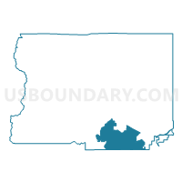
Boulder 19, Boulder County, Colorado
About
Outline

Summary
| Unique Area Identifier | 546956 |
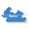
| Name | Boulder 19 |
| County | Boulder County |
| State | Colorado |
| Area (square miles) | 36.32 |
| Land Area (square miles) | 35.78 |
| Water Area (square miles) | 0.54 |
| % of Land Area | 98.50 |
| % of Water Area | 1.50 |
| Latitude of the Internal Point | 39.95550590 |
| Longtitude of the Internal Point | -105.26952270 |
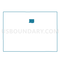
Maps

Graphs
Select a template below for downloading or customizing gragh for Boulder 19, Boulder County, Colorado


Neighbors
Neighoring Voting District (by Name) Neighboring Voting District on the Map
- 2162530003, Jefferson County, CO
- 2162530004, Jefferson County, CO
- 2162930001, Jefferson County, CO
- Boulder 121, Boulder County, CO
- Boulder 122, Boulder County, CO
- Boulder 123, Boulder County, CO
- Boulder 140, Boulder County, CO
- Boulder 151, Boulder County, CO
- Boulder 154, Boulder County, CO
- Boulder 155, Boulder County, CO
- Boulder 159, Boulder County, CO
- Boulder 161, Boulder County, CO
- Boulder 162, Boulder County, CO
- Boulder 164, Boulder County, CO
- Boulder 166, Boulder County, CO
- Boulder 167, Boulder County, CO
- Boulder 17, Boulder County, CO
- Boulder 171, Boulder County, CO
- Boulder 172, Boulder County, CO
- Boulder 20, Boulder County, CO
- Boulder 23, Boulder County, CO
- Boulder 26, Boulder County, CO
- Boulder 53, Boulder County, CO
Top 10 Neighboring County Subdivision (by Population) Neighboring County Subdivision on the Map
- Northeast Jefferson CCD, Jefferson County, CO (450,008)
- Boulder CCD, Boulder County, CO (115,643)
- Lafayette-Louisville CCD, Boulder County, CO (65,784)
- Golden CCD, Jefferson County, CO (35,260)
- Bald Mountain CCD, Boulder County, CO (12,286)
Top 10 Neighboring Place (by Population) Neighboring Place on the Map
- Boulder city, CO (97,385)
- Louisville city, CO (18,376)
- Superior town, CO (12,483)
- Paragon Estates CDP, CO (928)
- Eldorado Springs CDP, CO (585)
Top 10 Neighboring Unified School District (by Population) Neighboring Unified School District on the Map
- Jefferson County School District R-1, CO (537,431)
- Boulder Valley School District RE-2, CO (212,161)
Top 10 Neighboring State Legislative District Lower Chamber (by Population) Neighboring State Legislative District Lower Chamber on the Map
- State House District 33, CO (94,061)
- State House District 25, CO (72,603)
- State House District 13, CO (69,892)
- State House District 12, CO (69,766)
- State House District 10, CO (67,272)
- State House District 29, CO (65,730)
Top 10 Neighboring State Legislative District Upper Chamber (by Population) Neighboring State Legislative District Upper Chamber on the Map
- State Senate District 17, CO (141,285)
- State Senate District 16, CO (136,132)
- State Senate District 18, CO (122,287)
Top 10 Neighboring 111th Congressional District (by Population) Neighboring 111th Congressional District on the Map
Top 10 Neighboring Census Tract (by Population) Neighboring Census Tract on the Map
- Census Tract 125.11, Boulder County, CO (6,265)
- Census Tract 137.02, Boulder County, CO (5,952)
- Census Tract 98.08, Jefferson County, CO (5,714)
- Census Tract 606, Boulder County, CO (5,325)
- Census Tract 125.10, Boulder County, CO (4,316)
- Census Tract 125.07, Boulder County, CO (4,202)
- Census Tract 125.05, Boulder County, CO (4,102)
- Census Tract 605, Jefferson County, CO (4,040)
- Census Tract 614, Boulder County, CO (3,990)
- Census Tract 127.10, Boulder County, CO (3,685)
Top 10 Neighboring 5-Digit ZIP Code Tabulation Area (by Population) Neighboring 5-Digit ZIP Code Tabulation Area on the Map
- 80027, CO (31,034)
- 80302, CO (26,941)
- 80303, CO (22,361)
- 80403, CO (18,211)
- 80305, CO (16,874)
- 80007, CO (7,262)
- 80025, CO (253)